


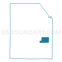
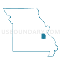
Hopewell Voting District, Washington County, Missouri
About
Outline

Summary
| Unique Area Identifier | 611549 |
| Name | Hopewell Voting District |
| County | Washington County |
| State | Missouri |
| Area (square miles) | 13.88 |
| Land Area (square miles) | 13.88 |
| Water Area (square miles) | 0.00 |
| % of Land Area | 99.96 |
| % of Water Area | 0.04 |
| Latitude of the Internal Point | 37.90034020 |
| Longtitude of the Internal Point | -90.73266990 |
Maps

Graphs
Select a template below for downloading or customizing gragh for Hopewell Voting District, Washington County, Missouri


Neighbors
Neighoring Voting District (by Name) Neighboring Voting District on the Map
- City Hall Ward II, Washington County, MO
- Irondale Voting District, Washington County, MO
- Ozark Heights Voting District, Washington County, MO
- Springtown Voting District, Washington County, MO
- Stony Point Voting District, Washington County, MO